Word Link and Word Bounce

APOLOGY – not really ICT based as my usual content on this blog is but is very much about teaching and learning.

These are two quick and easy activities for developing the use of terminology, consolidating understanding, applying knowledge and making synoptic links that I use with my A’level group.

AIM OF BOTH:

  • Increase familiarity with key terminology
  • Develop and consolidate understanding of the meaning of the key words
  • Develop the ability to apply understanding by showing that understand how the word and its meaning fits into the wider glacial topic
  • Can be used to help develop synoptic links and help students identify synoptic links more quickly if using vocabulary or named examples from across the spec.

The example below is Glaciation based (after the first few weeks of introducing the topic) but can be used at any time in the course and with any topic. It is good for checking as you go that students can see the links between the knowledge they are developing and is good for revision at the end of a topic.

It is really flexible – only involves writing words on board (so little prep needed) can be done with any topic – physical or human AND a variety of words from across topics to get the synoptic links going. (We are particularly focusing this year on trying to build student capacity to make links within and between topics throughout the A Level course). 

First you need a set of words – either on the whiteboard or given to students – for example..

Example word list

WORD LINK
– can just be done in pairs or teacher led asking individuals.

How does it work:
Either:
(i) give students any two words and they have to make a sentence which links them
e.g.   Accumulation and Equilibrium   – e.g. “when accumulation and ablation are the
same, equilibrium occurs.”

OR

(ii) Students have to choose two words that they are going to make a link between in a sentence.

WORD BOUNCE
done in a team – could do as a whole class or split into groups depending on class size (similar concept to Word link – but have to keep the chain of words going ‘bouncing’ between students….)

How does it work: Students to make a sentence with any two words on the board (so starts like work link) – e.g.

Student 1 “A cold based glacier is also known as a Polar Glacier.”

The next person has to start their sentence with the second word that the student before used so would start with Polar Glacier and link to another word – e.g.

Student 2 Polar Glaciers move by internal deformation

Next students has to start with internal deformation e.g.

Student 3Internal deformation includes processes such as Laminar flow

Student 4 “Laminar Flow does not occur in Temperate Glaciers”

Student 5 “Temperate glaciers are found at high altitude and are also known as warm based glaciers”

etc.

The challenge for the student becomes how to then link to another aspect – so the next student could change the focus from types of glacier to mass balance by then saying “Warm based glaciers will be in retreat if there is a negative mass balance“.

So basically students are ‘bouncing’ a word to the next in team to make a link between and build a sentence with – I have found that this can become very competitive as the aim is to keeping going from person to person for as long as possible without stopping – you could do it where they can use the same word twice in a different context – OR to make it harder – give them a copy of the key words and they have to tick them off as they use them so those words can’t be used again.


Using Technology in teaching KS4/KS5 Geography

I haven’t posted for a while due to the hectic nature of preparation for the new GCSE and A’level courses. Back in November however I gave a talk in London looking at Utilising Technology in Teaching KS4 and KS5 Geography and thought I would share the resources on here.

The handout can be downloaded here and has lots of direct weblinks and advice to support geography teachers in following up the ideas discussed.

The presentation given is below. Please feel free to contact me if you have any questions.

Apps for Geography Fieldwork

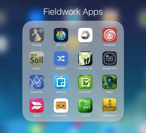
With preparations underway for fieldwork to support students with the new AS and A2 specifications and to provide them with tools that may be useful for their independent investigations I have been exploring options for useful apps to take into the field. The screenshot below is a small selection of some the key ones that we hope to use during fieldwork over the next couple of months. I will be reviewing some of these as and when we use them. For now just something to think about….

Page 1 – Fieldwork Apps
Picture1

Page 2 – Fieldwork AppsFieldwork Apps2

Free Online Earthquake Teaching Resource

natural-disastersNatural Disasters: Earthquakes

The British Red Cross, supported by the Geographical Association, has launched a new, free educational resource for geography teachers. Natural disasters: earthquakes is a curriculum-led geography teaching resource that draws on the recent experience of the  Red Cross during the 2015 Nepal earthquake.

Using case studies, maps and eyewitness accounts, this latest British Red Cross teaching resource provides a unique perspective on how individuals and communities prepare for, respond to and recover from earthquakes.

The British Red Cross, which provides a range of educational resources for teachers to download online, created this resource in response to research that showed geography teachers were looking for case study content that brought human stories into the classroom.

With the unique perspective of the Red Cross the humanitarian impact of a natural disaster is explored alongside understanding how earthquakes happen. Resources start with activities for all students and then differentiate into activities for Key Stage 3, GCSE and A level, a curriculum mapping document shows how the resource can contribute to the curricula of England, Scotland, Wales and Northern Ireland.  Natural disaster: earthquakes and can be downloaded for free from the British Red Cross website.

The resource will help students:

  • Learn about the physical geography, hazards and risks which can cause a natural disaster such as an earthquake.
  • Explain and analyse the varied impacts an earthquake may have on individuals and communities.
  • Gain insight into the role of the Red Cross in disaster preparedness, response and recovery.
  • Explore the concept of resilience and what might make a community more able to cope in a crisis.

Explore the ecological tapestry of the world – A New Global Ecosystems Map of unprecedented detail

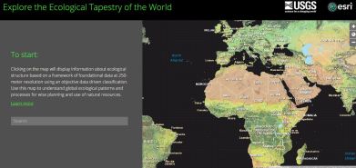
ecological tapestry of the world

This collaboration between ESRI and the USGS is the most detailed global ecological land units map in the world more details of which can found in this blog post. Very useful for looking at the application of GIS and enables further exploration through GIS with the availability of ready to use data layers which can be utilised in ArcGIS.

There are a number of ways to access the Global Ecological Land Units Map:

1. Explore the introductory story map which consists of two aspects:

  • 1. Ecosystem Browser – zoom in / pan out on the map and click anywhere to identify the name of the ecosystem found there.
  • 2. Ecosystem Tour – allows you to take a tour of areas with a high ecological landscape diversity

2. Explore the ecological tapestry of the world here in the online application

3. Use the content in ArcGIS to explore landscape analysis using ready prepared data layers from Esri.

4.  Detailed publication (.pdf format) detailing the approach taken to mapping global ecological land units

iPad Bulletin – issue 9 (Apps Focus – Geography)

iPad Bulletin 9

You may have noticed that at the moment this has become a fortnightly bulletin rather than weekly – mainly due to time pressures! Hopefully it will give people more time to digest and try things out! Click here to download this week’s bulletin.

Enhancing teaching and learning with ICT

This morning I was at Homerton in Cambridge working with the Faculty of Education PGCE Geography students, looking at the way ICT can be used to enhance the teaching and learning of geography. We talked about department websites, VLEs, blogs, wikis, podcasts and the Interactive Whiteboard. Obviously many ideas are generic and can easily be applied to other subject areas. So in case anyone would like to find out more, the presentation I gave is below and the follow up materials and links are available here. Give me a shout if you have any questions.